Off the Bricks

Pack 02

A Morbid Walking Tour of Boston

Bad Ends is a self-guided walk through the parts of Boston history that end badly, told by someone who checked. It starts at North Station and finishes at the Public Garden, about three hours and six kilometers, with a one-hour short cut and a late walk for after dark, and it plays as a riddle hunt: each clue gets you to the next spot, and you answer by reading something that is actually there, a date on a plaque or a word on a stone.

On the way you'll stand where a molasses tank killed twenty-one people, at a burying ground where the most famous bullet story is attached to the wrong grave, outside the building where Boston's first famous painless surgery happened, in a room that now holds an Egyptian mummy, and at the corner where a Harvard professor's crime came down to a set of false teeth. You'll find out who paid for the Common's upkeep, and why that's darker than it sounds, and which gravestone people call Hester Prynne's, and what the court record actually says. You'll stand over the place a transit commission moved about nine hundred people to build the first subway in America, and it kept the receipt.

Every legend on this walk is told as a legend first, then checked against court records, city reports, inscriptions and contemporary accounts. Some hold up. Some don't. Every source is listed on the sources page.

One stop on this route marks a modern disaster with many dead. It is a memorial, not a puzzle, and it is told plainly.

Any two stops are free. Bring good shoes for two hills, and go on a weekday between nine and four if you want the burying ground gates open.

Play any two stops free.

Route

01020304050607080910111213
Map data © OpenStreetMap contributors
  • The whole walk

    180 MIN · 6.2 KM · 13 STOPS

    Molasses to ether in thirteen stops: the whole Parkman murder, three burying grounds, two gallows arguments and a memorial. Weekday daytime, so the gates are open.

  • The short cut: the Parkman case

    65 MIN · 2.3 KM · 6 STOPS

    In an hour: the murder site and the teeth, the ether dome and its mummy, the victim's son paying for the Common, a gallows argument, the surgeon who explained the 'hanging tree', and 910 people under the subway with a receipt.

  • The late walk

    70 MIN · 3 KM · 6 STOPS

    Six stops that are outdoors with no burying-ground gates: Beacon Hill, the Common, Bay Village and the Public Garden. Built for evenings; the Common and Public Garden close late at night, so check the posted park hours. Bring a phone light: the Great Elm tablet and the Ether Monument's carved numerals are hard to read in the dark.

Stop 01 · North End

The company painted the molasses tank brown, the city's archivists say, so the leaks wouldn't show.

The company painted the tank brown, the city's archivists say, so the leaks wouldn't show. Neighbors complained they could see molasses seeping from the seams anyway. On January 15, 1919, the fifty-foot tank on this waterfront split open and put roughly 2.3 million gallons into the North End. Twenty-one people died and about 150 were hurt. The dead included two ten-year-olds, Pasquale Iantosca and Maria Distasio, and George Layhe, a firefighter at Engine 31. The company's first answer was anarchists. In April 1925, after hearings with about 3,000 witnesses, the court's auditor, Hugh W. Ogden, ruled that the owners' negligence was to blame. The physics came later. In 2016 Harvard researchers showed that the day was mild, then the temperature fell below freezing that night, and cold molasses can get four or more times thicker. Rescuers were digging people out of a substance that was setting around them. In 2019 UMass Boston archaeologists ran ground radar over the park looking for the base. They found a hard layer under the infield, then judged it most likely modern landscaping. Their best guess puts the tank about three meters northwest of where a 1917 map draws it. Nobody has dug.


Look now

Look across the ball field. The tank stood about here; the 2019 survey's best guess is a few meters northwest of where a 1917 map puts it.

Read more
100 years ago today: molasses crashes through Boston's North End - Boston City Archives
Stop 02 · North End

The 1851 record puts the bullet holes on a different grave.

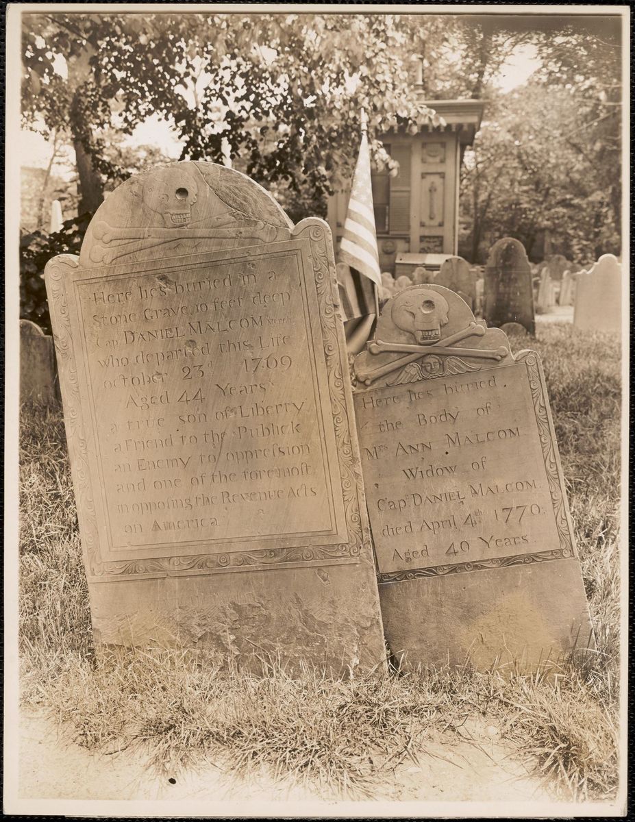
Leon Abdalian's photograph of Capt. Daniel Malcom's stone, Copp's Hill, ca. 1920-1960, with the pocks visible
Leon H. Abdalian, ca. 1920-1960. Boston Public Library, via Digital Commonwealth.

The pockmarks in this slate are Boston's favorite bullet story. Daniel Malcom, merchant, died 1769, asked to be buried in a stone grave ten feet deep, and his stone calls him 'a true Son of Liberty' and 'an enemy to oppression.' The British put a battery on this hill in 1775, and the story goes that the soldiers used Malcom's stone for target practice. Look at it: it's pitted. The city's own sign here repeats it, and is careful to open with 'Legend states.' Now the record. In 1851 Thomas Bridgman copied and published the epitaphs on this hill. He writes that soldiers from the battery 'used some of the gravestones for targets' and wrecked others with patriotic epitaphs. But the one stone he names as 'marked by the bullets of a British foe' is Grace Berry's, wife of Thomas Berry, plot C-30; one guide dates her death to 1695. Not Malcom's. The city's burying-ground page now says only that 'many have interpreted' the scars as musket balls. So the target-practice story is in print by 1851. Which stone took it is where the story drifted toward the better epitaph. Also, it's spelled MALCOM. The city's website and Old North's own blog both add an L.


Look now

Look at the pocks on Malcom's stone (D-86), then hunt for Grace Berry's (C-30). Bridgman called hers 'singularly shaped.'

Read more
Epitaphs from Copp's Hill Burial Ground (Thomas Bridgman, 1851) - Internet Archive

Detours

  • Warren's Museum: Phineas Gage's Skull
    From Arlington, Green Line E branch outbound (toward Heath Street) to Longwood Medical Area, about 15 minutes, then about 3 minutes outbound along Huntington Avenue to the public entrance at 695 Huntington Avenue. The gallery is only open to the public Saturdays 10-4 and Sundays 12-5, with government photo ID. Check before you go.
  • The Other Gallows: Boston Neck
    From the Mary Dyer statue, walk down Park Street and along Tremont Street to Boylston station (about 10 minutes). Board the Silver Line SL5 toward Nubian at the Tremont Street stop by Boylston station and ride to Washington Street at East Berkeley Street, about 10 minutes. Or walk it: about 25 minutes south on Tremont and Washington Streets.

Pit stops

  • Warm up inside · NEAR STOP 06
    Boston Public Library, West End Branch (151 Cambridge Street)
    Public library branch on Cambridge Street, between the Ether Dome and the Joy Street climb. Warm up inside during posted hours; closed Sundays. Check before you go.
    Boston Public Library
  • Restroom · NEAR STOP 13
    Seasonal public restrooms, MacArthur Mall, Boston Common
    Seasonal public restroom trailer on the Common near the Charles Street crossing to the Public Garden. Check the season and posted hours before you go.
    Friends of the Public Garden

107 sources